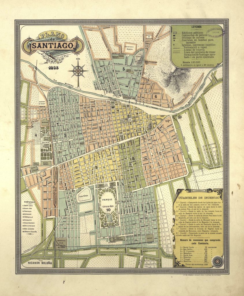
Santiago is the capital of Chile and today it has a population of around 18 million. This old map of Santiago was created by Nicanor Boloña, a mapmaker for the Office of Geography and Mines of the General Directorate of Public Works. It is unknown what exactly what the map was used for, but today it gives us insight into the geographic layout of Santiago from 1895.
The map features many prominent landmarks that make Chile unique that one can still visit today. The city is surrounded by various cerros or mountains such as Cerro Santa Lucía, Cerro Cristobal, and Cerro Blanco which are clearly labeled on the map. Quinta Normal which today is known at the museum district, even in this map one can see a square labeled “museo”. Plaza de armas . Streets are named after important people or places in Chile such as Antofagasta, Rancagua, A. Bellos, Bulnes, Rosas, and Portales to name a few. The western part of today’s Santiago was still not developed in 1895, but one can see the emergence with Avenida Providencia and Camino de Ñuñoa. While the names of the eight comunas of Santiago bear little resemblance to the current day comunas, there are still some that remain such as Recoleta, and other legacies. For example, “8 Universidad” continues to be an area filled with many universities and “4 Estación” with Estación Central, which has had multiple rebuilt stations, still continues to be located in the east of Santiago. Other notable landmarks include Plaza de Armas, Cementerio General, Parque Counsiño (today known as Parque O’Higgins), Club Hipico, and Rio Mapocho.
Sprinkled around the city on the map are some schools, fire barracks, hospitals, churches, a slaughterhouse, business, and factories. Agricultural was still a driving aspect of the economy as Chile, like much of Latin America, did not industrialize during this time which is evident on the map with the presence of few factories and businesses on the city map. Much of the area outside of the city appears desolate, but with some plans for transportation and developments. Even if Chile was not industrialized, the map still shows careful urban planning that resembled the modern metropolitan that Santiago would become. The details show the preciseness in the rectangles or squares of the city blocks and straight, clear cut roads. The map is color-coded according to comuna. There is no doubt that these early markers paved the way for a modern-day Santiago.
Today, Santiago is a bustling place with various communities. It is also a place with high inequality which is present in its geography. As the western part of Santiago became more developed, wealthy people moved there. The general trend of Santiago has been moving west. Today, the poorest cities in Santiago are located in the eastern part of Santiago, while the wealthiest neighborhoods lie in the western, northern part of Santiago. Maps, and the geography of a place in general, can tell us a lot about a city, both in the past and present day.
Works Cited:
“South America: Chile — The World Factbook – Central Intelligence Agency.” Accessed April 13, 2020. https://www.cia.gov/library/publications/the-world-factbook/geos/print_ci.html.
Memoria Chilena: Portal. “Plano de Santiago, 1895 – Memoria Chilena.” Accessed April 13, 2020. http://www.memoriachilena.gob.cl/602/w3-article-68088.html.
